Canada is currently experiencing the worst wildfire season in recorded history, with the total area of land burned so far this year breaking records not only at a national level, but for all of North America. Dry conditions and more frequent lightning storms caused by a dramatically changing climate are cited as the causes for the sheer number of fires this season, numerous and widespread enough to cause a decrease in air quality across the continent due to the smoke, affecting not only Canadians downwind of the fires but also impacting over 100 million people in the U.S.
So far, an area of nearly 8 million hectares (19,700,000 acres) have burned across Canada—an area equivalent to the size of South Carolina—with only the province of Prince Edward Island and the territory of Nunavut having been spared from any major fires. Approximately 5,000 firefighters from around the world, including personnel from Australia, France, New Zealand, Portugal, Spain, South Africa and the U.S., have travelled to help their Canadian counterparts tackle the record-breaking fires.
In the hardest hit province, Alberta saw an early start to its wildfire season in early March, with over 1,200,000 hectares (2,965,265 acres) having burned so far, equal to more than four fifths of the size of Connecticut. The provincial government declared a state of emergency on May 6, with over 29,000 people across numerous communities under evacuation orders.
Nova Scotia saw numerous wildfires, with one major conflagration burning at the southwest of the province, and the other near the province’s capital of Halifax, encroaching on the city’s suburb of Bedford; in all, over 18,000 people were evacuated across the province, with approximately 24,128 hectares (59,622 acres) having burned thus far.
Since early June, over 200 fires have raged in Ontario and Quebec, with at least 145 of them considered out of control, burning over 40,000 hectares (98,842 acres) of land to date, and prompting the evacuation of at least 14,500 residents across affected areas of Quebec.
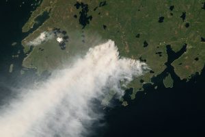
Smoke from the fires has seriously impacted air quality in Canada’s capital of Ottawa and its largest city, Toronto, prompting air quality warnings across not only eastern Canada but also in 20 U.S. states. Poor visibility caused the delay or cancellation of several flights between airports in New York City, New Jersey, and Washington, D.C.; the thick smoke prompted school closures in New York, New Jersey, and Connecticut. The haze reduced visibility in New York Harbor and New Jersey to just 1.2 miles (1.9 kilometers) on June 9.
“Air quality is unhealthy in every corner of the state,” New York Governor Kathy Hochul stated during a press conference. “This is the new normal for New Yorkers.”
Although air quality wasn’t impacted as heavily, the smoke also drifted across the Atlantic to Greenland and Iceland, and by June 25 had reached France, Portugal, Spain, and the U.K.; the far-reaching haze was also reported as far south as Mexico and Central America.
Although forest management techniques focusing on fire suppression, rather than controlled burns that would remove dry vegetation, are a factor in fueling the fires, an abnormally dry season coupled with a larger than usual number of lightning storms induced by climate change are being cited as the main cause of the severity of this season’s wildfires, with over half of the fires having started due to lightning strikes.
“These conditions, this early in the season, are unprecedented,” according to Public Safety Minister Bill Blair. “Due to climate change, similar extreme weather events may continue to increase in both frequency and severity across our country.”
Subscribers, to watch the subscriber version of the video, first log in then click on Dreamland Subscriber-Only Video Podcast link.
I forgot to include a link to the Canadian smoke forecast map, to help visualize the spread of the smoke: https://firesmoke.ca/forecasts/current/
And Nullschool’s satellite composite PM2.5 map: https://earth.nullschool.net/#current/particulates/surface/level/overlay=pm2.5/orthographic=-90.95,50.63,1570
And for the UFO C/R curious, Shag Harbour is in the second bay to the immediate left of the smoke plume in the image included with the article: https://www.barringtonmunicipality.com/Visiting-Us/shag-harbour-ufo-incident
Thanks for these smoke updates. It is unbearable to me that no US nor Canadian media this year have mentioned the need for children to shelter at home to avoid that smoke inhalation hazard. (I would suggest that under current smoke conditions, children only leave home for medical appointments.) To make it worse, there is also no media mention that US mask manufacturers are now allowed to manufacture one-size-fits-all masks, which of course don’t fit all. Years ago, Small Medium Large masks were available in the USA, but not anymore.