Earth’s closest celestial neighbors—Mars and Venus—couldn’t be more different in regards to the environments that each planet is home to, but two new discoveries—an ancient glacier at Mars’ equator and active volcanism on Venus—just serve to accentuate the diversity that exists amongst our planetary siblings.
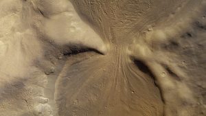
First up, ice: evidence of an ancient glacier has been discovered by the SETI Institute in a region at Mars’ equator called Noctis Labyrinthus (Latin for “Labyrinth of Night”), located at the western end of Valles Marineris, the massive system of canyons that carves a 4,000 kilometer (2,500 mile)-long gouge across the planet’s surface. The location of this prospective glacier is marked by what are termed light-toned deposits (LTDs), surface features that typically get their color from pale sulfate salts.
However, the deposits at Noctis Labyrinthus sport features seen on glaciers found here on Earth, such as crevasse fields and moraine bands, sprawling across a region 6 kilometers long by 4 kilometers wide (3.7 by 2.5 miles). While the presence of water itself hasn’t been verified, the minerals deposited there appear to form the imprint of a previously-flowing glacier.
“What we’ve found is not ice, but a salt deposit with the detailed morphologic features of a glacier,” explains study lead author Dr. Pascal Lee, a planetary scientist with the SETI Institute. “What we think happened here is that salt formed on top of a glacier while preserving the shape of the ice below, down to details like crevasse fields and moraine bands.”
The region is blanketed with a layer of ancient volcanic debris, a potential source for a layer of sulfates that, when the compounds come into contact with water ice, could form a crusty layer of sulfate salts on the surface of the glacier. Over time natural erosion would expose this layer of minerals, revealing the LTDs as they appear today.
While water ice has been discovered on the surface of Mars in the past (and possibly liquid water underneath the surface), those reservoirs were discovered near the planet’s polar regions; Noctis Labyrinthus is located at a latitude of just 7 degrees south of the equator, well within Mars’ tropics. And even if water ice is not currently present underneath the mineral deposits, the formations imply that water may have been present on Mars’ surface much longer than previously assumed.
Next, we get to fire: after decades of speculation into whether Venus is geologically active or not, an analysis of radar data from the Magellan spacecraft has revealed a volcano that was in the act of erupting when the probe mapped the planet’s surface in the early 1990s. At the time, the scans showed that 80 percent of Venus’ surface was covered by lava flows, but at the time there was no way to determine when these features were formed; were they due to activity that is going on today, or the remnants of seismic activity from millions, or even billions of years ago?
Being very similar to the Earth in regards to its internal composition, Venus has been long assumed to be geologically active, but the thick atmosphere prevents scans at the majority of light wavelengths, obscuring the surface from view. Over the decades there have been hints that the rocks on the surface are young enough to not have been affected too much by the planet’s highly corrosive atmosphere; thermal anomalies that hinted at lava flows and changes in the sulfur dioxide content of the atmosphere that could be due to volcanic eruptions were also found, but nothing definitively pointed to Venus being geologically active.
This led to a new study of the Magellan data at the University of Alaska that concentrated on what was determined to be the regions most likely to feature volcanic activity; the researchers’ search uncovered two images of Atla Regio, a region near Venus’ equator that is home to two of the planet’s largest volcanoes, Ozza Mons and Maat Mons, that showed features that appeared to be lava flows on the slopes of Maat Mons in an October 1991 image that were not present in an image taken the previous February.
The image also showed what appeared to be the expansion of a nearby volcanic vent that would appear to have been related to the downhill flow, with the crater having doubled in size in the eight months between the images, and having become more shallow in depth, an indication that lava may have welled up in the vent during the eruption.
Subscribers, to watch the subscriber version of the video, first log in then click on Dreamland Subscriber-Only Video Podcast link.